Introduction
For those navigating the realms of cartography, surveying, or simply exploring the vast landscape of geographic information, understanding how to convert OSGB36 coordinates to latitude and longitude is a crucial skill.
In this guide, I’ll explain how to convert from OSGB36 eastings and northings to latitude and longitude and vice-versa.
WGS84 vs ETRS89
For the purpose of this article, WGS84 and ETRS89 are considered the same. In most circumstances this won’t matter, but keep in mind there are differences between them.
Converting coordinates
Coordinate conversion is a complex topic and the in depth explanation is outside the scope of this article. I assume most people reading this will be interested in the practical aspect of converting coordinates. I will not provide too much technical information in this article. But if you want to deep dive into the details of it, there are a few resources which are ideal for understanding the process:
- A Guide to Coordinate Systems in Great Britain – written by Ordnance Survey.
- Convert between Latitude/Longitude & OS National Grid References – a short well written article explaining the conversions.
Prerequisites
In order to convert OSGB36 eastings and northings into Latitude and Longitude (ETRS89) and vice-versa we need to know two things:
- Which version of the OSGB36 coordinate system are we interested in?
- What’s the accuracy of the coordinates we are looking for?
Sample Data
Single Point Sample Data
ETRS89/WGS84 Coordinates
- Latitude: 53° 32′ 14.88″ N
- Longitude: 2° 15′ 1.96″ W
- Altitude (GRS80): 103.000m
OSGB36 (TN15/GM15)
- Easting: 383492.251
- Northing: 404562.756
- Height (ODN): 51.891
Bulk Conversion Sample Data
For bulk conversion I will be testing the coordinates provided by Ordnance Survey in their Developer Pack.
Point	Eastings	Northing	 Height
TP01	91492.146	11318.804	46.519
TP02	170370.718	11572.405	71.264
TP03	250359.811	62016.569	163.097
TP04	449816.371	75335.861	48.589
TP05	438710.920	114792.250	54.056
TP06	292184.870	168003.465	60.646
TP07	639821.835	169565.858	55.149
TP08	362269.991	169978.690	54.485
TP09	530624.974	178388.464	20.544
TP10	241124.584	220332.641	27.613
TP11	599445.590	225722.826	30.206
TP12	389544.190	261912.153	51.998
TP13	474335.969	262047.755	83.982
TP14	562180.547	319784.995	20.912
TP15	454002.834	340834.943	45.275
TP16	357455.843	383290.436	36.779
TP17	247958.971	393492.909	46.335
TP18	247959.241	393495.583	46.413
TP19	331534.564	431920.794	12.658
TP20	422242.186	433818.701	165.912
TP21	227778.330	468847.388	29.335
TP22	525745.670	470703.214	41.232
TP23	244780.636	495254.887	39.891
TP24	339921.145	556034.761	41.106
TP25	424639.355	565012.703	76.574
TP26	256340.925	664697.269	17.459
TP27	319188.434	670947.534	66.388
TP28	167634.202	797067.144	13.192
TP29	397160.491	805349.736	58.932
TP30	267056.768	846176.972	13.260
TP31	9587.906	899449.000	42.012
TP32	71713.131	938516.405	83.732
TP33	151968.652	966483.780	58.921
TP34	299721.891	967202.992	46.021
TP35	330398.323	1017347.016	47.956
TP36	261596.778	1025447.602	46.445
TP37	180862.461	1029604.114	85.349
TP38	421300.525	1072147.239	51.049
TP39	440725.073	1107878.448	100.989
TP40	395999.668	1138728.951	90.015
Point   Latitude	      Longitude	    Height
TP01	49.9222639373	-6.2997775201	100.000
TP02	49.9600613782	-5.2030461000	124.269
TP03	50.4388582561	-4.1086456356	215.251
TP04	50.5756366500	-1.2978227724	94.688
TP05	50.9312793791	-1.4505143370	100.405
TP06	51.4007822014	-3.5512834924	112.371
TP07	51.3744702555	1.4445473041	99.439
TP08	51.4275474302	-2.5440761835	104.018
TP09	51.4893656495	-0.1199255718	66.057
TP10	51.8589089640	-4.3085247696	81.351
TP11	51.8943663735	0.8972432701	75.274
TP12	52.2552938163	-2.1545861439	101.526
TP13	52.2516095123	-0.9124895697	131.594
TP14	52.7513668717	0.4015354707	66.431
TP15	52.9621910941	-1.1974765592	93.825
TP16	53.3448028019	-2.6404932081	88.411
TP17	53.4162851604	-4.2891806976	100.776
TP18	53.4163092542	-4.2891779287	100.854
TP19	53.7791102576	-3.0404549069	64.940
TP20	53.8002151963	-1.6637916824	215.609
TP21	54.0866631808	-4.6345216821	84.366
TP22	54.1168514429	-0.0777313319	86.778
TP23	54.3291954101	-4.3884911813	94.503
TP24	54.8954234042	-2.9382774115	93.542
TP25	54.9791227366	-1.6165768518	125.878
TP26	55.8539995295	-4.2964901625	71.617
TP27	55.9247826551	-3.2947921934	119.032
TP28	57.0060669605	-5.8283669185	68.494
TP29	57.1390251896	-2.0485603075	108.611
TP30	57.4862500072	-4.2192639856	66.178
TP31	57.8135183841	-8.5785445608	100.001
TP32	58.2126224718	-7.5925556056	140.404
TP33	58.5156036130	-6.2609145553	115.026
TP34	58.5812046128	-3.7263102212	98.634
TP35	59.0374387119	-3.2145400112	100.000
TP36	59.0933503532	-4.4175767460	100.000
TP37	59.0967161740	-5.8279933984	140.716
TP38	59.5347079449	-1.6251696606	100.000
TP39	59.8540991389	-1.2748691036	149.890
TP40	60.1330809166	-2.0738282280	140.716
Convert OSGB36 to Latitude and Longitude
Converting OSGB36 to Latitude and Longitude is very simple by using any of the tools listed in this article. As a general rule I recommend using Grid InQuest II. This has a few advantages:
- It’s a free, open-source software, provided by Ordnance Survey.
- It contains all required transformations for common coordinate systems in the UK to the newest version.
- It supports a variety of input and output formats, especially when it comes to angular values (Decimal Degrees, DMS, with or without symbols etc).
- Can handle single coordinate conversion as well as bulk conversions.
- It has a command line interface.
Convert a Single Point
When using Grid InQuest II for converting OSGB36 Easting and Northing to Latitude and Longitude do the following:
Step 1
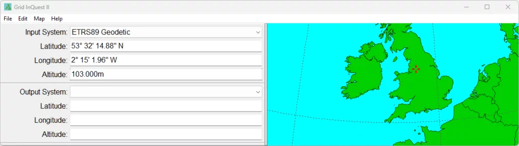
Open up the software. You will be presented with the following interface:
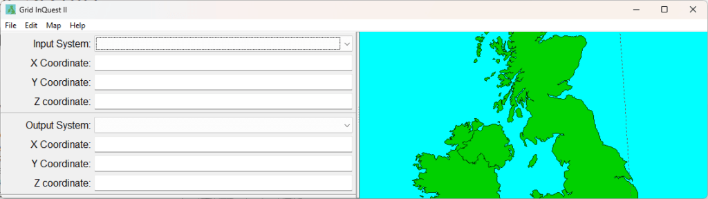
On the left is the data input form and on the right is a map of the UK showing where our data is located (a red crosshair).
Step 2
Select the correct input system (OSGB36 / British National Grid) and fill in the Easting, Northing and (optional) Elevation with the coordinates you want to transform.
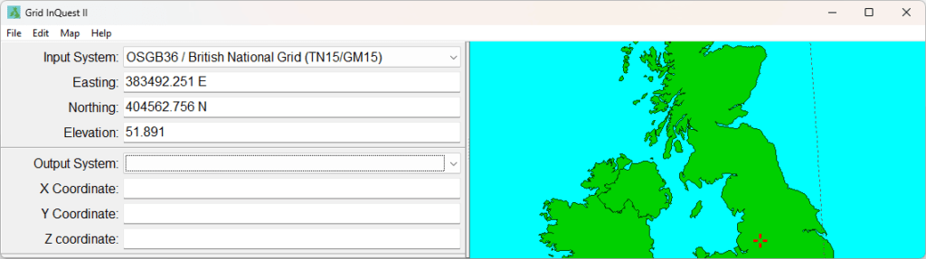
Step 3
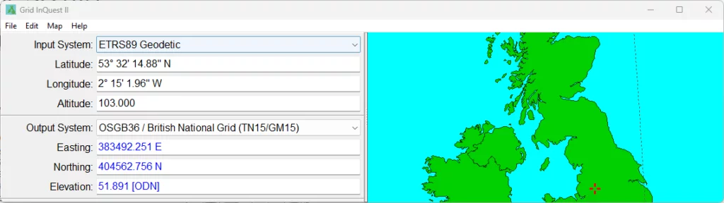
Select the desired Output System (ETRS89 Geodetic in this case). Conversion is done one the fly and are converted values are shown as Latitude, Longitude and Altitude (if height was provided).
Convert Multiple Points
Converting multiple coordinates is just as simple as a single point, with only a few extra steps. To convert multiple OSGB36 Eastings and Northings into ETRS89 (WGS84) Latitudes and Longitudes do the following:
Step 1
Start up the Grid InQuest II software.
Step 2
Select the file containing your points (File > Load Data Points…). If you don’t have one yet, you can create any text file with your points. Grid InQuest II accepts CSV files, TXT files and TSV files.

Step 3 (optional)
(Optional) If your file is a bit more complex, you can play around with the Data Settings to correct the input.
Step 4
Select the Input Coordinate System from the list. In this case it will be OSGB36 / British National Grid (TN15/GM15).
Step 5
Select the correct columns for Eastings & Northings. If you have vertical data in your file, make sure to check the Has Vertical Data box to enable it, and select the corresponding column.
Step 6
Select the desired Output Coordinate System. In this case it will be ETRS89 Geodetic.

Step 7 (optional)
You can Save your Data Configuration and load it next time when you want to do a bulk conversion.
Step 8
Press OK. The points will be loaded in and the interface of the software will change to a table view, listing your data.

Step 9
Press Transform Data to transform all coordinates. The software will list the transformed coordinates in ETRS89 in the table view.
Step 10
To save the data to a file, go to File > Save Data Points. This will create a text file containing all the loaded data and the corresponding coordinates in ETRS89.

Your results should be similar to the ETRS89 sample dataset provided above.
Convert Latitude and Longitude to OSGB36 Easting and Northing
The process of converting ETRS89 Latitude and Longitude to OSGB36 Easting and Northing is exactly the same as the process to convert Easting and Northing into Latitude and Longitude, but in reverse.
Convert a Single Point
When using Grid InQuest II for converting Latitude and Longitude to OSGB36 Easting and Northing do the following:
Step 1
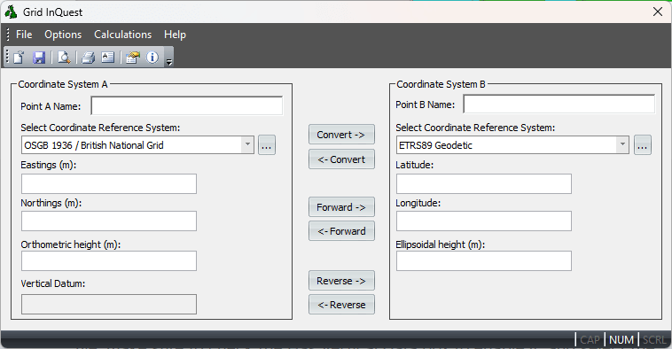
Open up the software. You will be presented with the now familiar interface:
Step 2
Select the correct input system (ETRS89 Geodetic) and fill in the Latitude, Longitude and (optional) Altitude with the coordinates you want to transform.
Note that the software is smart enough to accept and properly interpret different degree formats (decimal degrees, degrees & decimal minutes and DMS). It will also understand the sign of the value by using letters (E/W or N/S).
Step 3
Select the desired Output System (ETRS89 Geodetic in this case). Conversion is done one the fly and are converted values are shown as Latitude, Longitude and Altitude (if height was provided).
Convert Multiple Points
Converting multiple coordinates is just as simple as a single point, with only a few extra steps. To convert multiple OSGB36 Eastings and Northings into ETRS89 (WGS84) Latitudes and Longitudes do the following:
Step 1
Start up the Grid InQuest II software and select the file containing your data points (File > Load Data Points…).
Step 2 (optional)
If your file is a bit more complex, you can play around with the Data Settings to correct the input.
Step 3
Select the Input Coordinate System from the list. In this case it will be ETRS89 Geodetic.
Step 4
Select the correct columns for Latitude & Longitude. If you have vertical data in your file, make sure to check the Has Vertical Data box to enable it, and select the corresponding column for Altitude.
Step 5
Select the desired Output Coordinate System. In this case it will be OSGB36 / British National Grid (TN15/GM15).

Step 6 (optional)
As previously mentioned, you can Save your Data Configuration and load it next time when you want to do a bulk conversion.
Step 7
Press OK. The points will be loaded in and the interface of the software will change to a table view, listing your data.

Step 8
Press Transform Data to transform all coordinates. The software will list the transformed coordinates as OSGB36 coordinates in the table view.

Step 9
To save the data to a file, go to File > Save Data Points. This will create a text file containing all the loaded data and the corresponding coordinates in OSGB36.

Your results should be similar to the OSGB36 sample dataset provided above.
Tools used to convert OSGB36 coordinates
There are a variety of tools one can use to convert between OS coordinates and latitude & longitude. Below are only a few of these which can be used depending on your needs.
Grid InQuest
Grid InQuest is a software provided directly by Ordnance Survey that deals with transforming between ETRS89 (WGS84) and related coordinate systems used in the United Kingdom (OSGB36, Irish Grid and Irish Transverse Mercator).
The software can provide a three dimensional transformation incorporating geoid models.
A coordinate may be transformed in between any of the following:
- OSGB 1936 / British National Grid
- TM75 / Irish Grid
- IRENET95 / Irish Transverse Mercator
- ETRS89 Geocentric
- ETRS89 Geodetic
- ETRS89 / UTM Zone 29N
- ETRS89 / UTM Zone 30N
- ETRS89 / UTM Zone 31N
Note: Not all transformations will be valid. For example, you cannot transform TM75 coordinates to OSGB36 coordinates, as these do not cover the same areas.
Furthermore, depending on the location of your coordinates and the coordinate system, Grid InQuest will convert between ETRS89 Ellipsoidal Heights (GRS80) and the following datums:
- Newlyn (ODN)
- St Marys (Scilly Isles)
- Douglas02 (Isle of Man)
- Stornoway (Outer Hebrides)
- St Kilda
- Lerwick (Shetland Isles)
- Newlyn (Orkney Isles only)
- Fair Isle
- Flannans
- North Rona
- Sule Skerry
- Foula
- Malin Head
- Belfast Lough
Old Grid InQuest software can be downloaded from here.
Grid InQuest II
Grid InQuest II is the updated version of Grid InQuest, similarly provided by Ordnance Survey. This uses the updated Geoid and Transformation models when dealing with conversion between coordinate systems.

It is available both as a desktop application and command line tools, enables seamless conversion between global geodetic coordinates (ETRS89/WGS84) and the national coordinate systems of Great Britain and Ireland.
Coordinates are transformed using the latest OSGM15 geoid model and the corresponding polynomial transformation models (OSTN15 for Great Britain and OSi/OSNI for Ireland) for each projected coordinate system, ensuring accuracy and precision.
A coordinate may be transformed in between any of the following:
- ETRS89 / UMT Zone 29N
- ETRS89 / UMT Zone 30N
- ETRS89 / UMT Zone 31N
- ETRS89 Cartesian
- ETRS89 Geodetic
- Irish Grid (IG/GM15)
- Irish Transverse Mercator (ITM/GM15)
- OSGB36 / British National Grid (TN15/GM15)
Depending on where the coordinates are located, it will transform between ETRS89 ellipsoidal heights and the following orthometric height datums when the transformation involves one of the national projected coordinate systems:
- Ordnance Datum Newlyn [ODN]
- St Mary’s [MAR]
- Douglas02 [DOU]
- Stornoway15 [STO]
- Lerwick [LER]
- Orkney (Newlyn) [ORK]
- Malin Head [MAL]
- Belfast [BEL]
- Offshore [OFF]
- Outside Official Extent [OUT]
Grid InQuest II can be downloaded from here: OSTN15 OSGM15 transformation software (ordnancesurvey.co.uk).
UK Grid Tools Android App

UK Grid Tools (Grid Reference UK – OSGB36) This is a lightweight Android App that can convert coordinates from WGS89 (ETRS89) into OSGB36 (TN15/GM15) and viceversa by using the 20km Grid Model. Coordinates are accurate to 0.15m, but will be rounded to the nearest metre.
Additionally, the app provides UK Grid Reference values in different formats.
Whilst not ideal for sub-metre precision, it will provide a much grater accuracy than a simple Helmert transformation.
Other tools for OSGB36 coordinate conversion
The following tools can also be used to transform grid coordinates into latitude and longitude.
OSGB36 Online Coordinate Transformation Tool
Provided directly by Ordnance Survey, the Coordinate Transformation Tool allows for coordinate transformation between ETRS89 coordinates and OSGB36 (OSGM15/OSTN15) coordinates.
Additionally, the website allows for conversion between OSTN15/OSGM15 and OSTN02/OSGM02 coordinates and batch conversion of coordinates.
Grid Reference Finder
Grid Reference Finder is a tool that is useful for generic coordinate conversions and planning, but the results will not be very accurate as it uses a Helmert 7 Parameter Transformation to obtain the coordinates.
For the transformation from ETRS89 to OSGB36 in Britain, using a single Helmert transformation will give errors of up to 3m (95%) in plan and 3.5m (95%) plan and height, depending where in the country the points of interest are.
A Guide to Coordinate Systems in Great Britain