What is GNSS?
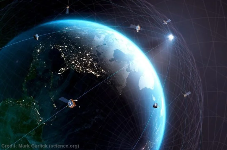
GNSS, or Global Navigation Satellite System, is a system that uses satellites orbiting the Earth to provide location and time information to users on the ground. GNSS systems consist of a network of satellites, ground control stations, and user equipment, such as GNSS receivers.
These systems use precise timing signals transmitted by the satellites to calculate the distance between the satellite and the receiver, and from this distance and the known position of the satellite, the receiver can determine its own position.
GNSS has a wide range of applications, including geomatics and land surveying, transportation and navigation, precision agriculture, and many others.
Use of GNSS in Geomatics and Land Surveying
GNSS is widely used in geomatics and land surveying to accurately determine the position and orientation of points on the Earth’s surface. This information is essential for creating maps, determining land boundaries, and performing various other tasks related to land management and development.
In geodetic surveying, GNSS is used to measure the size and shape of the Earth, which is necessary for creating accurate maps and understanding the Earth’s geodetic reference frame.
GNSS is also used in topographic surveying, which involves creating detailed maps of the Earth’s surface, and in cadastral surveying, which involves determining land boundaries and ownership.
Other uses of GNSS outside of Land Surveying
GNSS has many other applications outside of land surveying. It is used in a variety of transportation and navigation applications, such as air, sea, and land transportation. In these applications, GNSS is used to determine the precise location of vehicles and to guide them to their destination.
GNSS is also used in precision agriculture, where it is used to improve crop yields by precisely mapping and monitoring fields.
Other applications include surveying and mapping for natural resource management, environmental monitoring, targeting and weather forecasting.
Difference between GNSS and GPS, GLONASS, GALILEO, BEIDOU
There are several GNSS in operation around the world, including the Global Positioning System (GPS), the Russian GLONASS system, the European Union’s GALILEO system, and China’s BEIDOU system. Each of these systems has its own network of satellites and ground control stations, and they operate independently of each other. However, they all use similar principles to determine the position and time of receivers on the ground.
NAVSTAR-GPS
The Global Positioning System (GPS) was developed and implemented by the United States military in the 1970s, and it became fully operational in the 1990s. Now it’s being developed and maintained by the United States government.
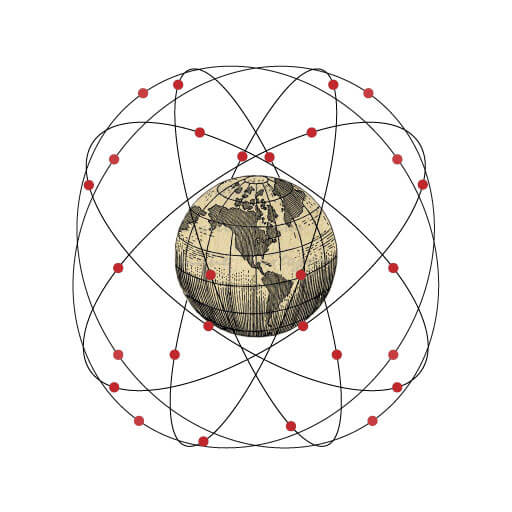
GPS consists of a network of 31 satellites orbiting the Earth at an altitude of about 20,200km. These satellites transmit signals that can be received by GPS receivers on the ground, allowing users to determine their precise location and time. GPS is the most widely used GNSS system in the world, and it is available for use by the general public free of charge.
GLONASS
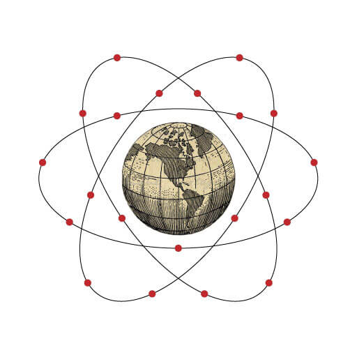
GLONASS (Globalnaya Navigazionnaya Sputnikovaya Sistema), or the Global Navigation Satellite System, is a space-based navigation system developed and maintained by the Russian government. This was initially developed by the Soviet Union in the 1980s, and it became fully operational in the 1990s.
It consists of a network of 27 satellites orbiting the Earth at an altitude of about 19,100 kilometres. These satellites transmit signals that can be received by GLONASS receivers on the ground, allowing users to determine their precise location and time. While GLONASS is not as widely used as GPS, it is still an important GNSS system and is available for use by the general public.
GALILEO
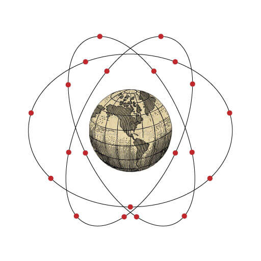
GALILEO is a space-based navigation system developed and maintained by the European Union and started as a project in 1990s, only becoming fully operational in April 2012. It consists of a network of 30 satellites orbiting the Earth at an altitude of about 23,222 kilometres.
These satellites transmit signals that can be received by GALILEO receivers on the ground, allowing users to determine their precise location and time. GALILEO is still in the process of being fully deployed, but it is already available for use by the general public.
BeiDou (BaiDou, or Big Dipper)
BEIDOU, or the BeiDou Navigation Satellite System, is a space-based navigation system developed and maintained by the Chinese government. Development of BeiDou officially started in 1994.
Currently, the BDS (BeiDou Navigation Satellite System) has 3 different types of satellites in orbits od different altitudes and inclinations. There are:
- 5 GEO (Geostationary Earth Orbit) satellites
- 7 IGSO (Inclined Geosynchronous Satellite Orbit) satellites
- 21 MEO (Medium Earth Orbit) satellites providing open services.
The GEO and IGSO satellites are located in orbits at an altitude of 35,786km, whilst the MEO satellites are in orbits with an altitude of 21,528km.
These satellites transmit signals that can be received by BeiDou receivers on the ground, allowing users to determine their precise location and time. BeiDou is primarily used in China and the surrounding regions, but it is also available for use by the general public. With the launch of BeiDou-3, this is set to become available globally.
Which GNSS system is the best: GPS, GLONASS, GALILEO or BEIDOU.
It is difficult to determine which GNSS system is the “best”, as each system has its own strengths and weaknesses.
- GPS is the most widely used and well-known GNSS system, and it has a long history of operation and development.
- GLONASS is also a reliable system and has the advantage of being able to provide coverage in high latitudes where GPS may have difficulty.
- GALILEO is a relatively new system, but it has the advantage of being under the control of a civilian authority, which may make it more trustworthy for some users.
- BEIDOU is primarily used in China and the surrounding regions, but it is also expanding its coverage and capabilities.
In terms of accuracy, all four systems are generally very accurate, with GPS and GLONASS typically providing the highest levels of accuracy. However, the accuracy of any GNSS system can be affected by various factors, such as the quality of the receiver, the number of satellites in view, and the presence of any interference or obstruction.
Overall, they are all valuable tool for a wide range of applications. Each system has its own strengths and weaknesses, and the best choice for a particular application will depend on the specific needs and requirements of the user.
Other GNSS Systems
In addition to the four major GNSS systems mentioned above, there are also several other regional and national GNSS systems in operation around the world. These systems are typically smaller in scale and are designed to provide coverage in specific regions or for specific applications.
Regional Systems
Regional GNSS systems are standalone GNSS systems that are designed to provide GNSS signals to users in a specific region or area. These systems typically have a smaller number of satellites and a more limited area of coverage compared to global GNSS systems such as GPS or GLONASS.
QZSS (Quasi-Zenith Satellite System):
QZSS is a regional GNSS system that is operated by the Japanese government in Japan. QZSS is designed to provide GNSS signals for users in Japan and the surrounding region, and it is used for a wide range of applications, including transportation, navigation, and surveying.
NavIC is a regional GNSS system that is operated by the Indian government in India. NavIC is designed to provide GNSS signals for users in India and the surrounding region, and it is used for a wide range of applications, including transportation, navigation, and surveying.
The NavIC system was previously known as IRNSS (Indian Regional Navigation Satellite System).
KASS (Korean Augmentation Satellite System)
KASS is a regional GNSS system that is operated by the Korean government in South Korea. KASS is designed to provide GNSS signals for users in South Korea and the surrounding region, and it is used for a wide range of applications, including transportation, navigation, and surveying.
Augmentation systems
GNSS (Global Navigation Satellite Systems) augmentation systems are used to improve the accuracy and reliability of GNSS positioning data. These systems can provide additional information about the location, velocity, and timing of GNSS satellites to help correct for errors in the data received by GNSS receivers on the ground.
There are several types of augmentation systems in use, including satellite-based augmentation systems (SBAS), ground-based augmentation systems (GBAS), and regional augmentation systems (RAS). Each of these systems operates in a slightly different way and is designed to meet specific needs and requirements.
Satellite Based Augmentation Systems (SBAS)
SBAS are global or regional systems that use a network of satellites and ground stations to provide correction signals to GNSS receivers. These systems can improve the accuracy of GNSS signals by providing correction data for atmospheric delays and ionospheric disturbances, as well as other errors. SBAS are relatively inexpensive to operate and can provide a wide area of coverage, making them a popular choice for many applications.
The following are examples of existing Satellite Based Augmentation Systems:
- Wide Area Augmentation System (WAAS): This is an SBAS system developed and operated by the United States Federal Aviation Administration (FAA) to improve the accuracy and availability of GPS data for aviation applications.
- European Geostationary Navigation Overlay Service (EGNOS): This is an SBAS system developed and operated by the European Union to improve the accuracy and availability of GPS and Galileo data for a variety of applications.
- Multi-functional Satellite Augmentation System (MSAS): This is an SBAS system developed and operated by the Japanese government to improve the accuracy and availability of GPS data for a variety of applications.
Ground Based Augmentation Systems (GBAS)
GBAS systems are ground-based systems that use a network of ground stations to provide correction signals to GNSS receivers. These systems are typically used in high-precision applications, such as land surveying and aviation. GBAS can provide very high levels of accuracy. GBAS systems are generally more expensive to operate than SBAS systems and have a more limited area of coverage.
Regional Augmentation Systems (RAS)
RAS systems are regional systems that are designed to provide correction signals for a specific area or region. These systems are typically used in applications where a high level of accuracy is required over a limited area, such as in aircraft landing and take-off. RAS systems can be more expensive to operate than other augmentation systems, but they can provide very high levels of accuracy.
Augmentation systems can be a useful tool for improving the accuracy and reliability of GNSS signals, but they also have some limitations and challenges. For example, augmentation systems are an additional cost and can become expensive to operate and maintain. And they may require specialized equipment and software to process the correction signals. Additionally, augmentation systems will not be available in all areas, and their coverage will be limited.
GNSS multi-constellation systems
One important aspect of GNSS is the use of multi-constellation systems, which combine signals from multiple GNSS systems to provide improved coverage and accuracy. Multi-constellation systems can use signals from any combination of GNSS systems, including GPS, GLONASS, GALILEO, BEIDOU, and others. By combining signals from multiple systems, multi-constellation systems can improve the availability and accuracy of GNSS services in various regions and under different conditions.
Multi-constellation systems are becoming increasingly common, as they offer several advantages over single-constellation systems. For example, multi-constellation systems can provide improved coverage in areas where the coverage of a single GNSS system may be limited. They can also provide improved accuracy, as the combined signals from multiple systems can help to reduce errors and improve the overall precision of the system.
Another advantage of multi-constellation systems is that they can provide a level of redundancy, which can be important in applications where reliability is critical. For example, in transportation and navigation applications, a multi-constellation system can provide an additional layer of safety by providing a backup in the event that one of the GNSS systems experiences a failure or outage.
There are also some potential challenges and limitations to using multi-constellation systems. For example, the integration of signals from multiple systems can be complex, and it may require specialized equipment and software to process the combined signals. Additionally, multi-constellation systems may be more expensive to operate and maintain, as they require a larger number of satellites and ground control stations.
Overall, multi-constellation systems offer many benefits and can be a useful tool in a variety of applications. However, they also have some limitations and challenges, and the specific suitability of a multi-constellation system will depend on the needs and requirements of the user.
Limitations of GNSS
It is worth mentioning that there are also several limitations and challenges to the use of GNSS.
Availability
One of the main limitations is the reliance on satellite signals, which can be disrupted or obstructed by various factors such as buildings, trees, and other objects. This can be especially problematic in urban or densely forested areas, where the satellite signals may be more difficult to receive.
The availability of the signals can be affected by various factors such as the number of satellites in view, the quality of the receiver, and the presence of any interference or obstruction. In some cases, GNSS signals may be unavailable or unreliable, which can be a problem for applications that rely on the accuracy and reliability of the signals. To address this issue with GNSS, you can use various techniques and technologies, such as multi-constellation systems and redundant systems, to improve the availability of the signals.
Cost
Another limitation of GNSS is the cost of the equipment and infrastructure required to use them. While the cost of GNSS receivers has been decreasing over time, they can still be expensive, especially for high-precision applications such as surveying and mapping. Additionally, the cost of operating and maintaining GNSS systems, including satellites and ground control stations, can be significant.
Security & Privacy
There are also some concerns about the security and privacy of GNSS, as the signals transmitted by the satellites can be monitored and potentially exploited by malicious actors. This can be a concern for applications where the security and privacy of the users is a priority, such as military and intelligence operations.
Limited accuracy
The accuracy of GNSS signals can vary depending on the specific system and conditions. While GNSS systems are generally very accurate, with an accuracy of a few meters or less in most cases, there are various factors that can affect the accuracy of the signals. These factors can include atmospheric delays, ionospheric disturbances, multipath errors, and other errors that can degrade the accuracy of the signals. To address these errors, GNSS systems use various techniques and technologies, such as augmentation systems, precise point positioning, and real-time kinematic positioning, to improve the accuracy of the signals.
GNSS Hardware
Finally, it is worth mentioning that the accuracy and reliability of GNSS signals can be affected by the quality of the receiver being used. GNSS receivers come in a range of different types and quality levels, and the accuracy and reliability of the signals will depend on the specific receiver being used. In general, higher-quality receivers will provide more accurate and reliable signals, but they may also be more expensive and require more specialized equipment and software.
Despite these limitations and challenges, GNSS has proven to be a reliable and essential tool for a wide range of applications, and they are likely to continue to be an important part of many fields in the future. By addressing these limitations and challenges, GNSS users can ensure that they are able to take full advantage of the capabilities and benefits of GNSS systems.
Final thoughts on GNSS
In summary, GNSS is a valuable and essential tool for a wide range of applications, and it is likely to continue to play a crucial role in many fields in the future.
[…] GNSS is a term used to describe satellite-based systems that provide positioning, navigation, and timing (PNT) data […]